Software and Hardware System GeoRad-M

Software and Hardware System GeoRad-M

  • Used to construct mobile radiological or radiochemical laboratories
  • Displays measurement results linked to a geographic map
  • Works with OpenStreetMap, Google Maps and Google Earth electronic maps
Order Got a question?

Feedback

[recaptcha]
  • Description
  • Description
  • Description
  • Description

Description

The system is used to construct mobile radiological or radiochemical laboratories. It is fixed on the vehicle.

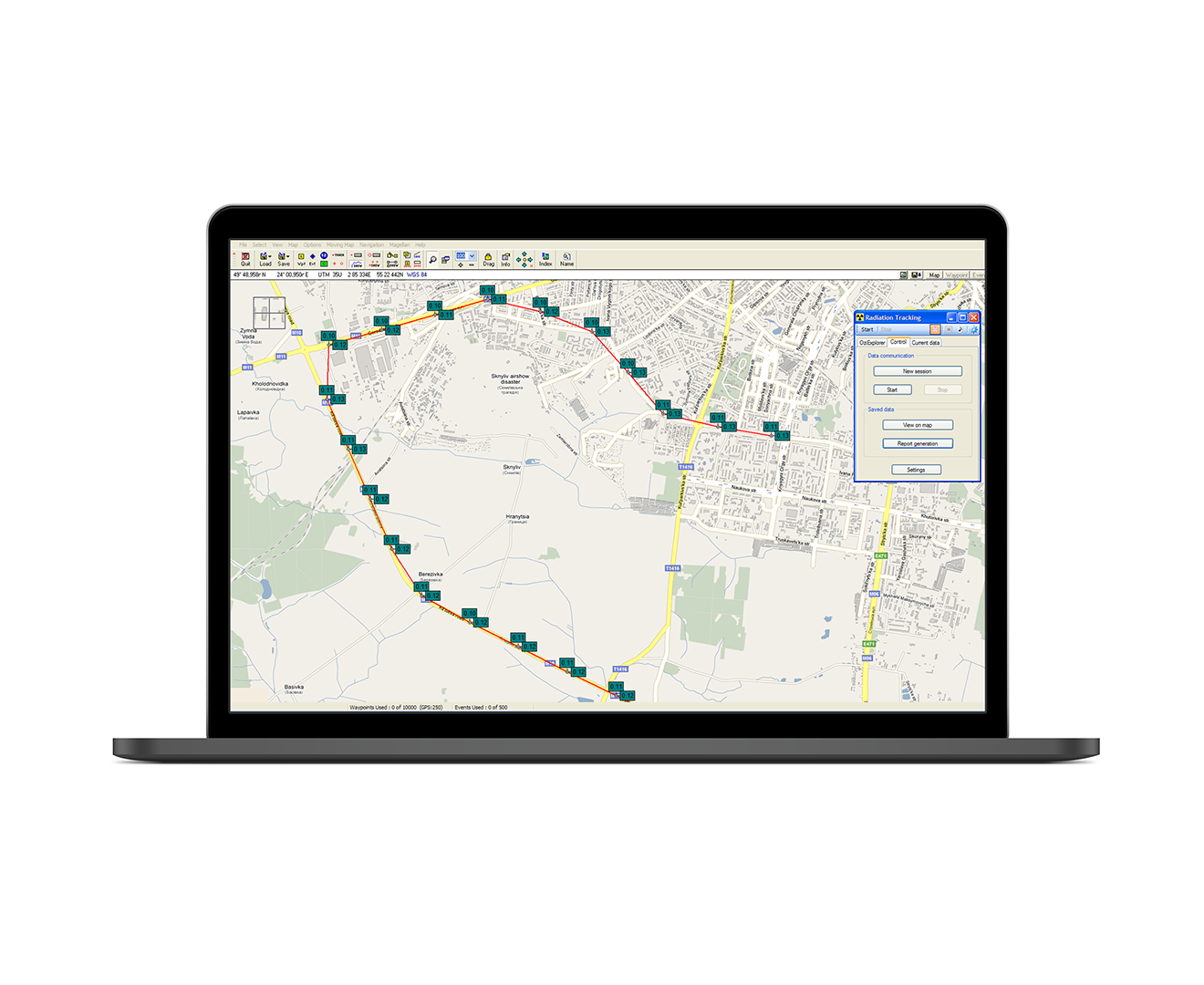
GeoRad-M consists of the BDBG-09 gamma radiation detecting unit (other detecting units with a similar exchange protocol are possible), the BS-09 Geo unit, a GPS antenna and custom-made software “GRad”.

GeoRad-M is intended to measure ambient dose equivalent rate of gamma radiation with reference to geographic coordinates (obtained from the navigation satellites). The results of measurements are displayed on a geographical map on the screen of a personal computer.

Purpose of Use

  • Measure ambient dose equivalent rate (DER) of gamma radiation and receive geographic coordinates from the navigation satellites

  • Display measurement results linked to a geographical map on the screen of a personal computer (PC), as well as archive this information

Features

  • Records measurement results of gamma radiation DER, as well as geographic coordinates and measurement time with an one second interval

  • Displays measurement results on the PC screen as a text and as route points linked to a geographic map. There are two modes of displaying/saving information – in a specified time or when moving to a given distance

  • Two threshold levels can be set – the warning threshold level and the danger threshold level of gamma radiation DER

  • Signals when the measured DER exceeds the set threshold levels with sound signals and a change in the color of information displayed on the PC screen and with light and sound alarm on the BS-09 Geo unit

  • Signals failures of the detecting unit and the BS-09 Geo unit with sound signals and messages on the PC screen. Sound signals about exceeding threshold levels and equipment failure are also generated by the PC acoustic system

  • Works with OpenStreetMap, Google Maps and Google Earth electronic maps

Specifications


Measuring instrument for gamma radiation DER BDBG-09 detecting unit of gamma radiation or similar detecting unit
Range of gamma radiation DER measurements* 0.05 … 107 μSv/h
Main relative permissible error limit during measurement of gamma radiation DER when calibrated by 137Cs with a confidence probability of 0.95* (15+2/H*(10)) %, where H*(10) is a numerical value of gamma radiation DER, equivalent to μSv/h
Energy range of registered gamma radiation* 0.05 … 3 MeV
Energy dependence of measurement results during gamma radiation DER measurement in the energy range from 0.05 MeV to 1.25 MeV* ±25 %
Navigation system** GNSS
Maximum root-mean-square error in location determination** 2.5 m
“Cold” start time** 35 s
“Hot” start time** 2.5 s
Power supply voltage when powered via PoE Ethernet connector** 25 … 60 V
Voltage from an external power supply via a separate connector and mains power via a connector for RS-485** 12 … 32 V
Useful current**, no more 1 А
PC connection interface** Ethernet
* Data for the BDBG-09 gamma radiation detecting unit ** Data for BS-09 Geo unit

Delivery Kit

  • BDBG-09 detecting unit of gamma radiation
  • BS-09-Geo unit
  • GPS antenna
  • BDBG-09 cable
  • Power cable
  • Ethernet cable
  • Antenna cable
  • GRad software
  • * A personal computer with the GRad program installed can also be included in the delivery kit at the customer’s request.
erty